
ShipAtlas by Maritime Optima


 Download
  Application Description
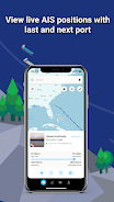
ShipAtlas by Maritime Optima is a must-have app for anyone interested in vessel tracking and maritime activities. With real-time AIS position data from over 700 satellites and terrestrial senders, you can track vessels and get valuable information about trades, port activities, sea routes, marine weather, ice conditions, piracy zones, and marine maps. The app collects raw AIS data for the global merchant fleet every second and processes it to provide you with high-quality data. You can search for specific vessels or ports, calculate sea routes, create vessel lists, set notifications, access daily marine information, and much more. The app offers a user-friendly interface, data synchronization across devices, and a dedicated support chat.
Features of ShipAtlas by Maritime Optima:
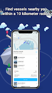
- Comprehensive tracking and trade information: Users can access data on port activities, sea routes, marine weather, ice conditions, piracy zones, and marine maps.
- High-quality data: The app ensures the accuracy and reliability of the collected AIS data through data wrangling and cleaning processes.
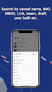
- Vessel search options: Users can search for specific vessels by name, IMO or MMSI numbers, or port names and types. Additional details such as LOA, beam, draft, and year built can be used for more specific searches.
- Sea route calculator: The app offers a quick and easy-to-use calculator that provides estimated time of arrival, distance in nautical miles, time at sea, and estimated bunker consumption for various sea routes.
- Customizable vessel lists and real-time tracking: Users can create unlimited vessel lists based on their search criteria and track the vessels in real-time on the map.
Conclusion:
ShipAtlas by Maritime Optima is a user-friendly app that provides real-time AIS position information and a wide range of tracking and trade-related data. With its high-quality data, easy-to-use interface, and features like the sea route calculator, the app is a useful tool for anyone interested in vessel tracking. While most features are free, users can enhance their experience by upgrading to a paid subscription for access to additional features. Download ShipAtlas by Maritime Optima now to start exploring the world of maritime navigation and information. Visit our website to learn more.
Screenshot
 Reviews
Post Comments+
Reviews
Post Comments+
ShipAtlas est un outil formidable pour suivre les navires, mais le prix est un peu élevé. Les données en temps réel sont précises, mais l'interface pourrait être améliorée.
ShipAtlas ist sehr nützlich für die maritime Überwachung, aber die Kosten sind hoch. Die Echtzeitdaten sind detailliert, doch die Benutzeroberfläche könnte benutzerfreundlicher sein.
ShipAtlas 对海事爱好者来说是个很好的工具,实时数据非常详细。不过,价格有点贵,界面也需要更友好一些。
ShipAtlas is an excellent tool for maritime enthusiasts. The real-time data is incredibly detailed and the interface is user-friendly. It's a bit pricey, but worth it for the amount of information you get.
ShipAtlas es útil para seguir el tráfico marítimo, pero la interfaz podría ser más intuitiva. Los datos en tiempo real son buenos, pero el costo es alto para lo que ofrece.
Latest Apps
MORE+
-
 RD Tunnel PRO - Unlimited VPN
Lifestyle 丨 12.86M
 Download
-
 BowlScore 10
Personalization 丨 3.20M
Download
-
 GoalBlitz : Euro 2024 Score
Personalization 丨 12.70M
Download
-
 TVmatsit - Urheilua tv:ssä
Personalization 丨 32.70M
Download
-
 Adobe Scan: PDF Scanner, OCR
Lifestyle 丨 16.20M
Download
-
 MIUl Carbon Icon Pack Mod
Personalization 丨 100.80M
Download
Similar recommendations
MORE+
Top News
MORE+


 Topics
MORE+
Topics
MORE+
- Essential Media and Video Tools for Android Users
- Best Apps for Following Current Events
- Top Photography Apps for Beginners
- Best Beauty Apps for Makeup Tutorials
- Realistic Simulation Games Collection
- Addictive Offline Games You Can Play Without Internet
- Top Casual Games for Mobile
- Top Multiplayer Battle Games for Android
Trending apps
MORE+
-
1

Migraine Buddy: Track Headache68.57M
Discover Migraine Buddy: Track Headache: Your Ultimate Migraine CompanionJoin the 3.5 million migraine sufferers who trust Migraine Buddy: Track Headache, the app designed to help you understand and manage your migraines. Here's how Migraine Buddy: Track Headache can help you: Pinpoint Patterns: Quickly identify triggers and patterns in your mi
-
2

Smart Life - Smart Living53.49M
The Smart Life app revolutionizes the way we control and manage our smart devices, bringing convenience and peace of mind to our everyday lives. This user-friendly app makes connecting and controlling a wide range of smart devices easier than ever before. Effortlessly set your devices to function ex
-
3

Обои для Стандофф 2 HD22.39M
Experience the adrenaline-pumping world of Standoff 2 like never before with "Wallpapers for Standoff 2." This must-have app is a treasure trove of vibrant and epic wallpapers that will transport you straight into the heart of the game. Whether you're a fan of popular characters, powerful weapons, t
-
4

RealVNC Viewer: Remote Desktop6.5 MB
Access your computer from anywhere using RealVNC Viewer! This Android app transforms your phone into a remote desktop, providing seamless control of your Mac, Windows, and Linux machines. RealVNC Viewer lets you remotely view and control your computer's desktop, mouse, and keyboard as if you were s
-
5

Cuevana 8 Mod11.43M
Cuevana 8 Mod APK is a leading app in the world of streaming, offering a wide range of high-quality movies and series. This app, which originates from the renowned Cuevana website, has been providing top-notch content for over two decades. Cuevana 8 Mod APK is popular for its user-friendly interface
-
6

Билеты ПДД 2023: экзамен ГИБДД36.35M
The Билеты ПДД 2023: экзамен ГИБДД app is your ultimate resource for acing the Russian theoretical driving exam. This comprehensive application covers all 40 exam questions and answers for categories ABM and CD, ensuring up-to-the-minute accuracy by referencing the official ГИБДД website. Prepare
6.5 MB
Download36.35M
Download14.48M
Download184.57M
Download60.6 MB
Download44.03M
Download