
スーパー地形 - GPS対応地形図アプリ
Category:Maps & Navigation Developer:kashmir3d
Size:16.7 MBRate:3.3
OS:Android 5.0+Updated:May 10,2025

 Download
  Application Description
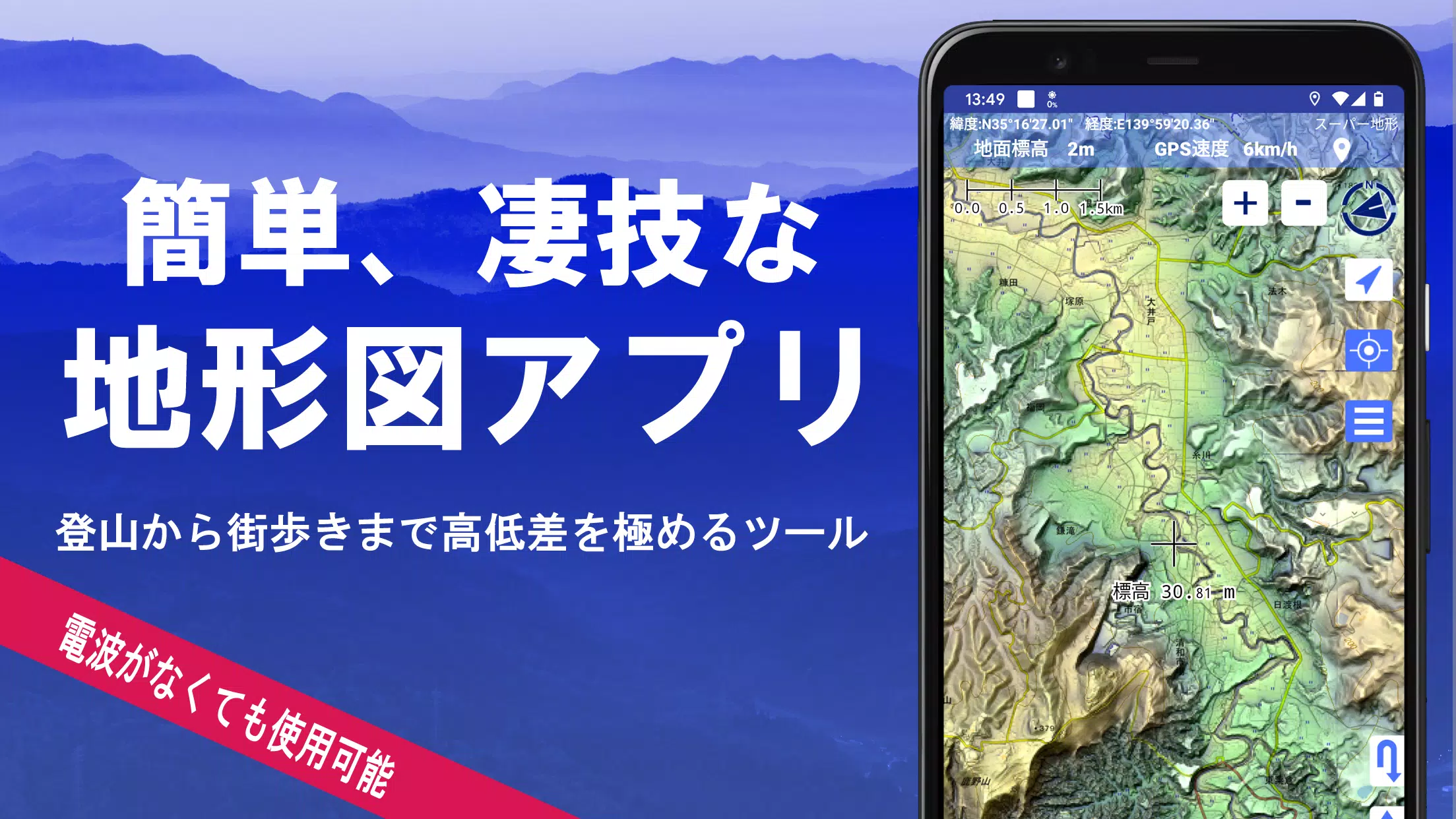
Discover the power of Super Terrain, a comprehensive mapping application that offers over 100 types of maps, including those from the Geographical Survey Institute. Whether you're climbing mountains or exploring urban landscapes, these maps help you make the most of height differences and geographical features.
Super Terrain was honored with the 2018 Japan Cartographic Society Award for Best Work, reflecting its outstanding contribution to cartography and outdoor navigation. The app utilizes "super terrain data" to enhance terrain visualization, providing users with a detailed and immersive experience.
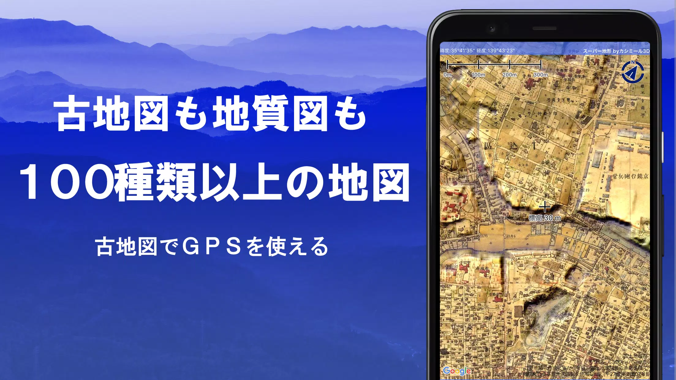
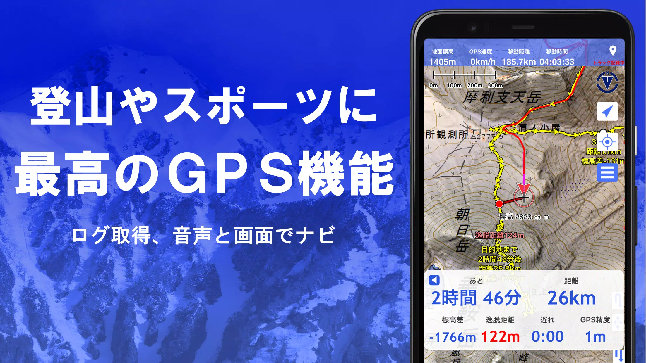
With access to a wide range of maps from the Geospatial Information Authority of Japan, including topographic, geological, old, historical, and prewar maps, Super Terrain ensures you have the tools you need for any journey. The app also supports GPS tracking, allowing you to record and edit your trajectories with GPX log input/output functionality.
Designed to enhance your outdoor activities, Super Terrain offers features such as GPS navigation with audio support, data recording, and editing. You can determine visibility for cross-sectional diagrams, observations, and radio communications, with the option to display buildings. A 360° panoramic view function identifies mountains, and you can view the sun, moon, and GPS points on the map.
For offline use, Super Terrain provides a bulk map download and map cache function, ensuring you're covered even in remote areas without a signal. Additional features include associating photos with points, displaying contour lines from elevation data, showing MGRS grids, and supporting GeoJSON files for GIS data manipulation and shape drawing.
Super Terrain is not limited to Japan; it can be used overseas and supports map printing and PDF output. A dark theme is available for better visibility in various lighting conditions.
A Wealth of Maps at Your Fingertips
Super Terrain offers over 100 types of maps, including our proprietary super topographic data, maps from the Geospatial Information Authority of Japan, and hazard maps. Aerial photographs are available by age group, with the "Latest" and "around 1974" having broader coverage. Maps using super terrain data are free for 5 days after installing the app.
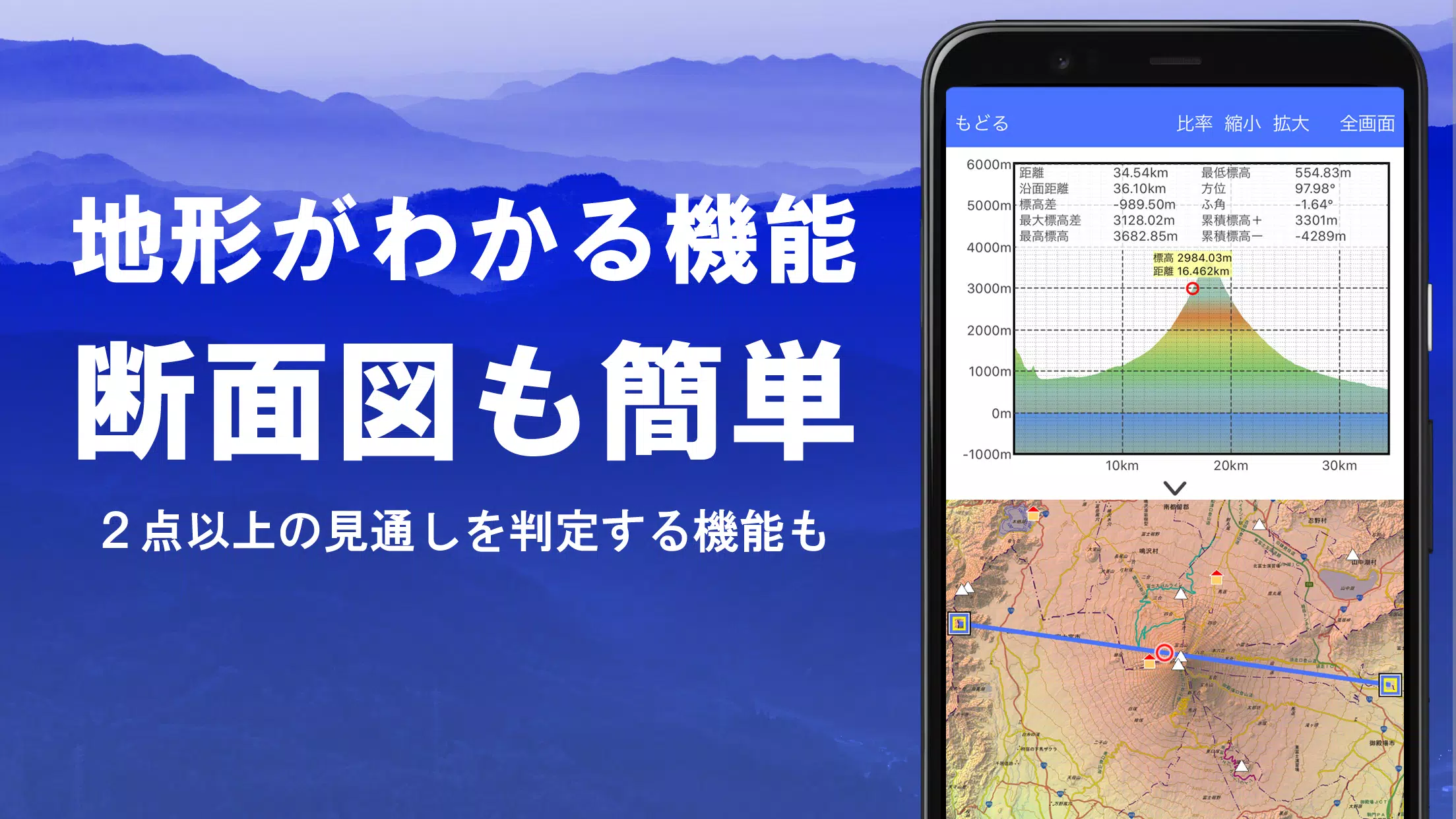
Creating Cross Sections and Outlooks
Easily draw cross-sections through any point on the map with Super Terrain. The app includes a visibility judgment function that accounts for the Earth's curvature and atmospheric conditions, making it ideal for route planning during climbs, assessing wireless visibility, and understanding terrain. Where PLATEAU building data is available, you can include buildings in your cross-sectional views.
Elevation Palette Function
Customize your map experience with the elevation palette function, which allows you to change the map background color in 1cm increments, creating a personalized gradation effect.
Panoramic View
With Super Terrain, you can view a panoramic observation map that labels mountains from any location. The 360° panorama integrates with your smartphone's compass, aiding in mountain identification. You can also view the sun and moon, including moon phases, which is perfect for spotting Diamond Fuji and Pearl Fuji. GPS points and overseas mountain panoramas are also viewable.
GPS Function
Utilize your smartphone's GPS to obtain location information and record tracks. Super Terrain supports high-precision positioning for serious outdoor and mountain climbing activities. Tracks are graphically displayed with parameters such as elevation, speed, time, and elapsed time. The point alarm function alerts you with voice and sound as you approach a designated point. You can display photos linked to specific points and send map center positions to NaviCon.
GPS Track Summary Playback
Replay your recorded tracks with Super Terrain's track summary playback feature. The app automatically matches and displays photos based on their capture times, showing icons at the photo locations for easy viewing.
GPS Navigation Function
Navigate along preset tracks with Super Terrain's Track Navi feature, which uses your smartphone's GPS. If you stray from the track, you'll be alerted by voice or sound, ensuring you stay on course during your climbs. The app also supports route navigation for urban exploration and point navigation to reach a single destination.
GPS Data Editing Function
Manage GPS-related point, route, and track data with Super Terrain. Organize data in folders and view them in an easy-to-read tree format. Create tracks directly on the map and import or export data in GPX format from climbing sites.
Offline Map Usage
Use maps even in areas without a signal, such as during mountain climbs, thanks to Super Terrain's bulk download function. You can download all scale maps of a specified plot and easily monitor download progress to avoid being without a map on-site. The app also includes a cache function for offline use.
Map History Function
Super Terrain remembers your viewed locations, allowing you to return to previous spots easily.
Custom Map Compatibility
Import and use custom maps created with Kashmir 3D's map cutter. Display and utilize your own maps and scanned images by dividing them into approximately 256 x 256 images and sending the resulting KMZ file to Super Terrain via email or cloud drive.
GeoJSON Compatibility
Work with GeoJSON files to display and edit points, linestrings, and polygons. You can also draw new shapes on the map.
Print/PDF Output
Print any map area at a specified scale or create a PDF for your records.
Integration with Other Apps
Super Terrain supports input and output of GPS data in GPX, KML, and GDB formats, allowing data exchange with other apps, Kashmir 3D on your PC, and trajectory data from mountain climbing sites.
Backup Function
Back up all app data (excluding cached maps) and remove it from your smartphone. Restore data even if the app is deleted or your device malfunctions. An automatic backup feature using Google Drive ensures your data is always up-to-date. Refer to the manual for detailed instructions.
Billing Function
Some features, such as maps using super terrain data, GPS track functions, and cross-sectional views, require in-app purchases. After payment, the number of place name search results increases. The annual fee is 780 yen, and a 5-day free trial is available upon first installation. To purchase, navigate to [Settings] - [Purchase to remove functional restrictions] within the app. You can check or cancel automatic updates through Google Play. Prices may be revised with future enhancements, so early purchase is beneficial.
Terms of Use
The copyright holder and developer are not responsible for the outcomes of using this application. When starting GPS for the first time, you'll be prompted to allow location services. Continuous GPS use can drain your battery, so carry a spare if your device is used for emergency communication. An explanation of the navigation function is available in PDF format at this link. Note that some smartphones may interrupt or fail to record tracks due to power-saving features, a common issue across apps. Turning off the screen while using Super Terrain may temporarily maintain recording, but it's not a permanent solution.
Screenshot
 Reviews
Post Comments+
Latest Apps
MORE+
Reviews
Post Comments+
Latest Apps
MORE+
-
 POPxo - Take It Up A Pop!
Communication 丨 11.60M
 Download
-
 Subject 9 — Motion Furry Comic
News & Magazines 丨 9.90M
Download
-
 Mangamo Manga & Comics
News & Magazines 丨 20.09M
Download
-
 King Social Auto Liker
Tools 丨 3.00M
Download
-
 Coub
Coub
Lifestyle 丨 109.60M
Download
-
 NaughtyDate
Lifestyle 丨 10.70M
Download
Similar recommendations
MORE+
Top News
MORE+


 Topics
MORE+
Topics
MORE+
- Essential Media and Video Tools for Android Users
- Best Apps for Following Current Events
- Top Photography Apps for Beginners
- Best Beauty Apps for Makeup Tutorials
- Realistic Simulation Games Collection
- Addictive Offline Games You Can Play Without Internet
- Top Casual Games for Mobile
- Top Multiplayer Battle Games for Android
Trending apps
MORE+
-
1

Migraine Buddy: Track Headache68.57M
Discover Migraine Buddy: Track Headache: Your Ultimate Migraine CompanionJoin the 3.5 million migraine sufferers who trust Migraine Buddy: Track Headache, the app designed to help you understand and manage your migraines. Here's how Migraine Buddy: Track Headache can help you: Pinpoint Patterns: Quickly identify triggers and patterns in your mi
-
2

Smart Life - Smart Living53.49M
The Smart Life app revolutionizes the way we control and manage our smart devices, bringing convenience and peace of mind to our everyday lives. This user-friendly app makes connecting and controlling a wide range of smart devices easier than ever before. Effortlessly set your devices to function ex
-
3

Обои для Стандофф 2 HD22.39M
Experience the adrenaline-pumping world of Standoff 2 like never before with "Wallpapers for Standoff 2." This must-have app is a treasure trove of vibrant and epic wallpapers that will transport you straight into the heart of the game. Whether you're a fan of popular characters, powerful weapons, t
-
4

RealVNC Viewer: Remote Desktop6.5 MB
Access your computer from anywhere using RealVNC Viewer! This Android app transforms your phone into a remote desktop, providing seamless control of your Mac, Windows, and Linux machines. RealVNC Viewer lets you remotely view and control your computer's desktop, mouse, and keyboard as if you were s
-
5

Cuevana 8 Mod11.43M
Cuevana 8 Mod APK is a leading app in the world of streaming, offering a wide range of high-quality movies and series. This app, which originates from the renowned Cuevana website, has been providing top-notch content for over two decades. Cuevana 8 Mod APK is popular for its user-friendly interface
-
6

Билеты ПДД 2023: экзамен ГИБДД36.35M
The Билеты ПДД 2023: экзамен ГИБДД app is your ultimate resource for acing the Russian theoretical driving exam. This comprehensive application covers all 40 exam questions and answers for categories ABM and CD, ensuring up-to-the-minute accuracy by referencing the official ГИБДД website. Prepare
20.9 MB
Download28.2 MB
Download82.4 MB
Download57.7 MB
Download169.7 MB
Download194.2 MB
Download