
All-In-One Offline Maps

Category:Maps & Navigation Developer:Psyberia
Size:7.2 MBRate:4.5
OS:Android 2.1+Updated:May 10,2025

 Download
  Application Description
OfflineMaps provides you with a comprehensive selection of maps for your adventures!
No advertisements ~ No data sharing & monetization ~ No analytics ~ No third party libraries
Tired of waiting for maps to load? With All-In-One OfflineMaps, once displayed, maps are saved and remain accessible, even without a network connection.
• Looking for more than just road maps? You'll find everything you need right here;
• Traveling to areas with limited network coverage? Your maps will always be available;
• Heading abroad? Say goodbye to getting lost;
• Concerned about data limits? This app will help you reduce your data usage.
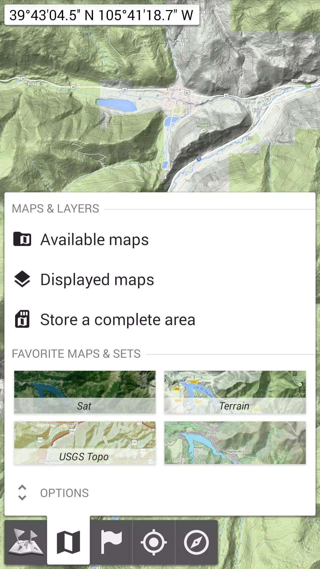
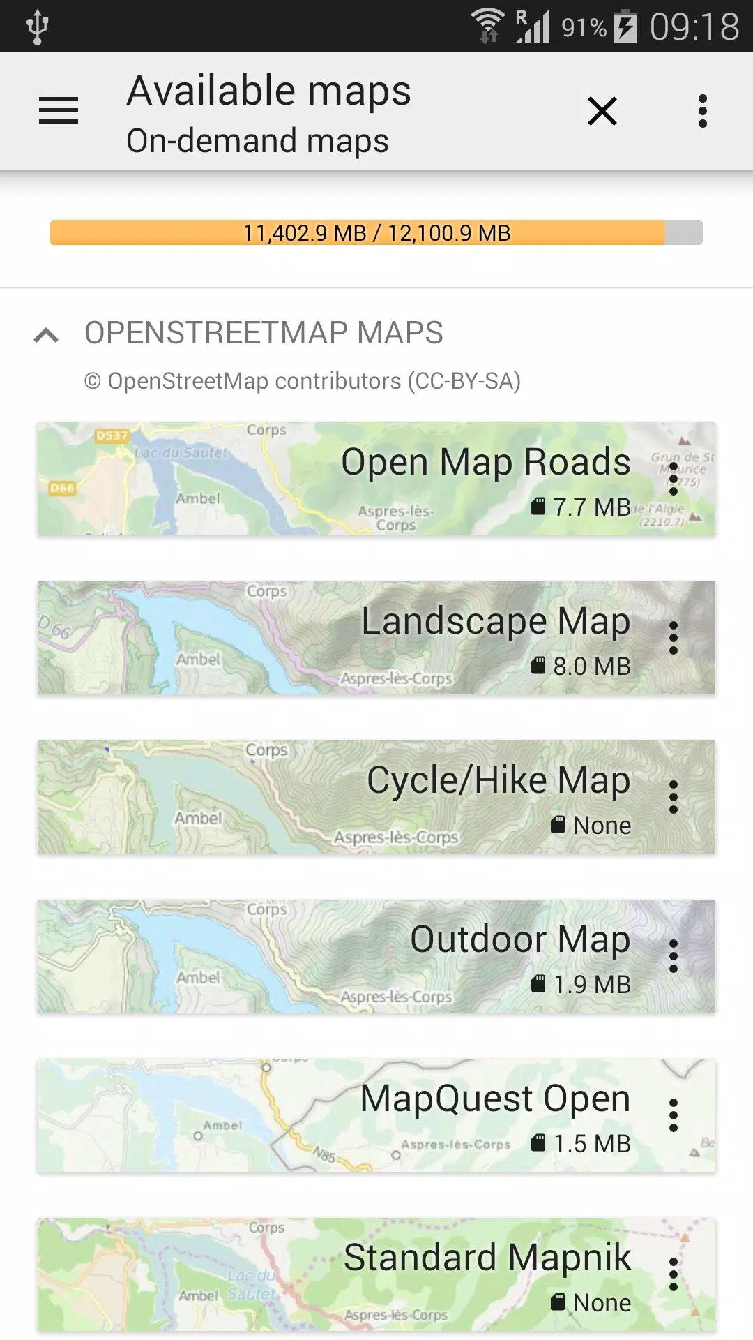
★★ Maps ★★
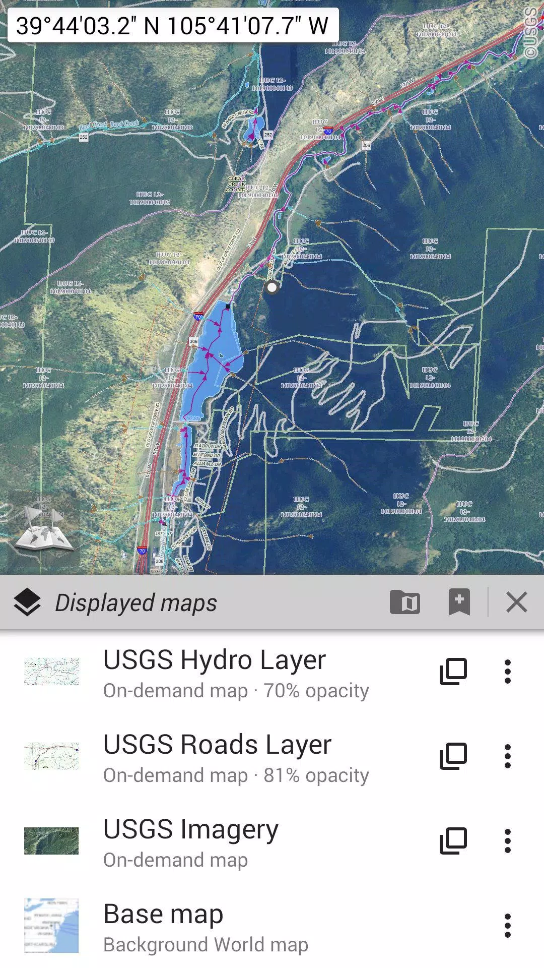
Explore a variety of maps, including classic road maps, topographic maps, aerial (satellite) maps, and additional layers that can be overlaid on any map: OpenStreetMap (Roads, Topo), USGS National Map (Hi-res topo, Aerial imagery), Worldwide Military Soviet topo maps, and more.
• Layer multiple maps with adjustable opacity;
• Easily select and save large areas with just a few clicks;
• Manage your stored map data effortlessly, with options to delete as needed.
★★ Display, Store, and Retrieve Unlimited Placemarks ★★
Add various elements to your maps, such as waypoints, icons, routes, areas, and tracks.
Easily organize and manage these items using the robust SD-Card Placemarks Explorer.
★★ On-Map GPS Location & Orientation ★★
See your exact location and direction on the map, which can be rotated to align with your real-world orientation (depending on your device's capabilities).
Toggle the feature on and off to conserve battery life.
And more:
• Choose between metric, imperial, and hybrid distance units;
• Use GPS Latitude/Longitude and a variety of grid coordinate formats (UTM, MGRS, USNG, OSGB Grid, Irish Grid, Swiss Grid, Lambert Grids, DFCI Grid, QTH Maidenhead Locator System, and more);
• Import numerous coordinate formats from https://www.spatialreference.org;
• Display on-map grids;
• Enjoy full-screen map views;
• Use multi-touch zoom;
• ...
★★ Need More? ★★
For the ultimate outdoor experience, consider AlpineQuest Off-Road Explorer, built on All-In-One OfflineMaps and featuring an advanced GPS Track Recorder and more: https://www.alpinequest.net/google-play
Screenshot

 Reviews
Post Comments+
Latest Apps
MORE+
Reviews
Post Comments+
Latest Apps
MORE+
-
 Game Turbo 4.0
Tools 丨 56.70M
 Download
-
 Social Networks 3D Media Cube
Communication 丨 8.50M
Download
-
 ユアユニ UR-University
Communication 丨 19.60M
Download
-
 KDO Vastipatrak
Communication 丨 20.20M
Download
-
 Real Follower & Hashtag AI
Personalization 丨 12.10M
Download
-
 Yo Movies
Video Players & Editors 丨 13.20M
Download
Similar recommendations
MORE+
Top News
MORE+


 Topics
MORE+
Topics
MORE+
- Essential Media and Video Tools for Android Users
- Best Apps for Following Current Events
- Top Photography Apps for Beginners
- Best Beauty Apps for Makeup Tutorials
- Addictive Offline Games You Can Play Without Internet
- Realistic Simulation Games Collection
- Top Casual Games for Mobile
- Top Multiplayer Battle Games for Android
Trending apps
MORE+
-
1

Migraine Buddy: Track Headache68.57M
Discover Migraine Buddy: Track Headache: Your Ultimate Migraine CompanionJoin the 3.5 million migraine sufferers who trust Migraine Buddy: Track Headache, the app designed to help you understand and manage your migraines. Here's how Migraine Buddy: Track Headache can help you: Pinpoint Patterns: Quickly identify triggers and patterns in your mi
-
2

Smart Life - Smart Living53.49M
The Smart Life app revolutionizes the way we control and manage our smart devices, bringing convenience and peace of mind to our everyday lives. This user-friendly app makes connecting and controlling a wide range of smart devices easier than ever before. Effortlessly set your devices to function ex
-
3

Обои для Стандофф 2 HD22.39M
Experience the adrenaline-pumping world of Standoff 2 like never before with "Wallpapers for Standoff 2." This must-have app is a treasure trove of vibrant and epic wallpapers that will transport you straight into the heart of the game. Whether you're a fan of popular characters, powerful weapons, t
-
4

RealVNC Viewer: Remote Desktop6.5 MB
Access your computer from anywhere using RealVNC Viewer! This Android app transforms your phone into a remote desktop, providing seamless control of your Mac, Windows, and Linux machines. RealVNC Viewer lets you remotely view and control your computer's desktop, mouse, and keyboard as if you were s
-
5

Cuevana 8 Mod11.43M
Cuevana 8 Mod APK is a leading app in the world of streaming, offering a wide range of high-quality movies and series. This app, which originates from the renowned Cuevana website, has been providing top-notch content for over two decades. Cuevana 8 Mod APK is popular for its user-friendly interface
-
6

Билеты ПДД 2023: экзамен ГИБДД36.35M
The Билеты ПДД 2023: экзамен ГИБДД app is your ultimate resource for acing the Russian theoretical driving exam. This comprehensive application covers all 40 exam questions and answers for categories ABM and CD, ensuring up-to-the-minute accuracy by referencing the official ГИБДД website. Prepare
20.9 MB
Download28.2 MB
Download82.4 MB
Download169.7 MB
Download57.7 MB
Download99.45 MB
Download