


 Download
  Application Description
2GIS offers a comprehensive suite of mapping and navigation tools designed to make exploring new cities and navigating familiar ones a breeze. With features like offline maps, GPS navigation, live traffic updates, parking information, and transit routes, 2GIS ensures you're never lost, even without an internet connection.
Feel at home in any city with 2GIS:
- Effortlessly locate addresses, businesses, contact details, operating hours, products, and services.
- Discover how to reach your destination by car, bus, subway, or follow pedestrian navigation.
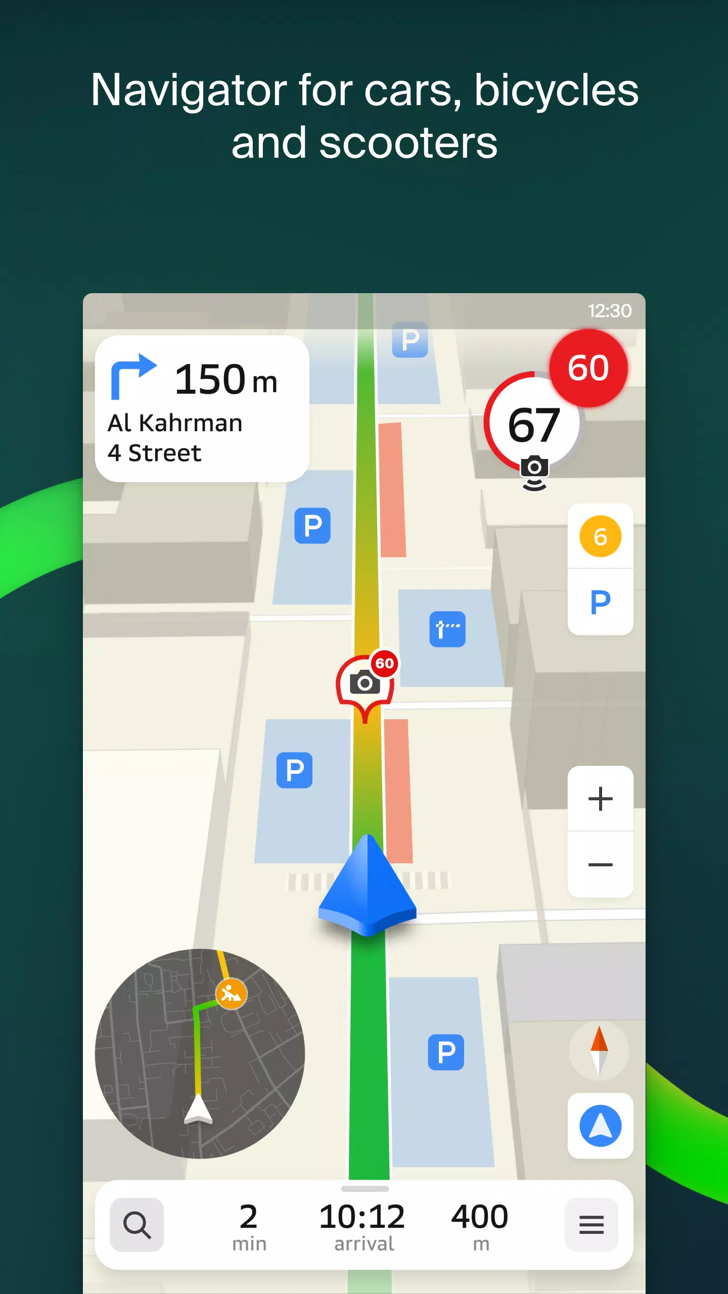
- Identify building entrances and nearby parking facilities.
2GIS provides precise maps, helping you pinpoint districts, buildings, streets, bus stops, subway stations, gas stations, sports facilities, and more.
The GPS navigation feature takes into account real-time traffic, road signs, speed cameras, toll roads, and unpaved routes, offering directions between cities and through multiple points. There's also a free app compatible with Android Auto.
Stay connected with loved ones using 2GIS's live friends' location tracking on the map. Ensure the safety of your children or friends, send stickers, and check their battery levels. You control who can see your location and can adjust sharing settings at any time.
Stay updated with road events, including accident reports, blocked streets, and speed camera notifications, all directly on the map.
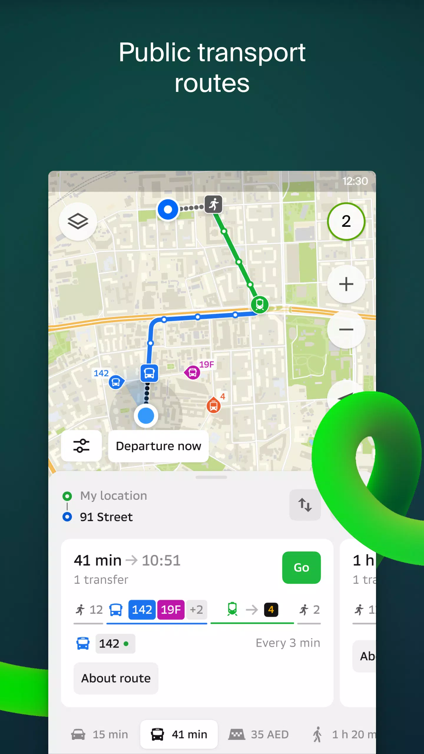
Navigate public transport effortlessly with 2GIS, which provides real-time transit schedules and routes.
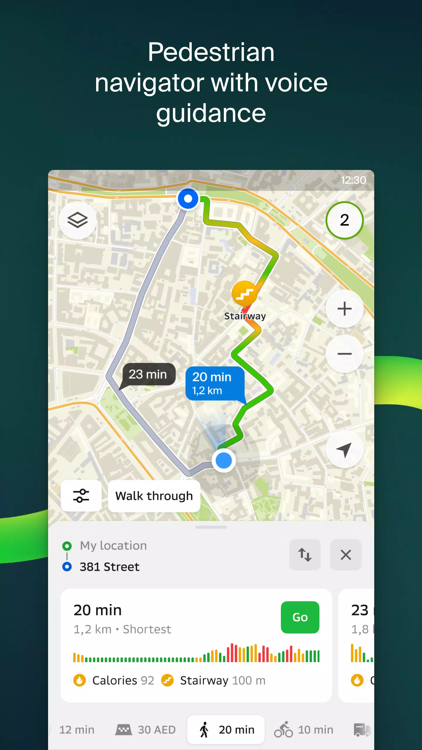
Pedestrian routes are available for walking navigation, working in the background with voice guidance for a seamless experience.
For truck drivers, 2GIS offers specialized navigation, considering the unique characteristics of your vehicle and cargo.
Access a detailed directory that includes addresses, entrances, postal codes, phone numbers, operating hours, social media links, websites, and user-added photos and reviews of businesses.
Explore like a local with 2GIS's travel guide, highlighting key attractions, places with Wi-Fi, and more.
Enhance your navigation experience with the 2GIS Notifications companion app for smartwatches on Wear OS. This app, compatible with Wear OS 3.0 and later, allows you to view maps, receive maneuver hints, and get vibration alerts for turns or approaching bus stops directly from your wrist.
2GIS covers numerous cities across various countries, including:
- Cities in the UAE: Dubai, Sharjah, Abu Dhabi, Al Ain, Ajam, Ras Al Khaimah, Fujairah, Umm Al Quwain, Dibba Al Fujairah, Khor Fakkan, Kalba, Al Salamh, and more.
- Cities in Russia: Moscow, Saint Petersburg, Novosibirsk, Ekaterinburg, Krasnoyarsk, Chelyabinsk, Ufa, Omsk, Kazan, Perm, Nizhny Novgorod, Sheregesh, and others.
- Cities in Belarus, Kazakhstan, Uzbekistan, Azerbaijan, and Kyrgyzstan: Minsk, Pavlodar, Semey, Aktau, Aktobe, Almaty, Nur-Sultan, Bishkek, Karaganda, Kokshetau, Kostanay, Osh, Baku, Tashkent, and more.
For any support, reach out to [email protected].
Screenshot

 Reviews
Post Comments+
Latest Apps
MORE+
Reviews
Post Comments+
Latest Apps
MORE+
-
 Trikatlón Tres Cantos
Lifestyle 丨 23.00M
 Download
-
 POPxo - Take It Up A Pop!
Communication 丨 11.60M
Download
-
 Subject 9 — Motion Furry Comic
News & Magazines 丨 9.90M
Download
-
 Mangamo Manga & Comics
News & Magazines 丨 20.09M
Download
-
 King Social Auto Liker
Tools 丨 3.00M
Download
-
 Coub
Coub
Lifestyle 丨 109.60M
Download
Similar recommendations
MORE+
Top News
MORE+


 Topics
MORE+
Topics
MORE+
- Essential Media and Video Tools for Android Users
- Best Apps for Following Current Events
- Top Photography Apps for Beginners
- Best Beauty Apps for Makeup Tutorials
- Realistic Simulation Games Collection
- Addictive Offline Games You Can Play Without Internet
- Top Casual Games for Mobile
- Top Multiplayer Battle Games for Android
Trending apps
MORE+
-
1

Migraine Buddy: Track Headache68.57M
Discover Migraine Buddy: Track Headache: Your Ultimate Migraine CompanionJoin the 3.5 million migraine sufferers who trust Migraine Buddy: Track Headache, the app designed to help you understand and manage your migraines. Here's how Migraine Buddy: Track Headache can help you: Pinpoint Patterns: Quickly identify triggers and patterns in your mi
-
2

Smart Life - Smart Living53.49M
The Smart Life app revolutionizes the way we control and manage our smart devices, bringing convenience and peace of mind to our everyday lives. This user-friendly app makes connecting and controlling a wide range of smart devices easier than ever before. Effortlessly set your devices to function ex
-
3

Обои для Стандофф 2 HD22.39M
Experience the adrenaline-pumping world of Standoff 2 like never before with "Wallpapers for Standoff 2." This must-have app is a treasure trove of vibrant and epic wallpapers that will transport you straight into the heart of the game. Whether you're a fan of popular characters, powerful weapons, t
-
4

RealVNC Viewer: Remote Desktop6.5 MB
Access your computer from anywhere using RealVNC Viewer! This Android app transforms your phone into a remote desktop, providing seamless control of your Mac, Windows, and Linux machines. RealVNC Viewer lets you remotely view and control your computer's desktop, mouse, and keyboard as if you were s
-
5

Cuevana 8 Mod11.43M
Cuevana 8 Mod APK is a leading app in the world of streaming, offering a wide range of high-quality movies and series. This app, which originates from the renowned Cuevana website, has been providing top-notch content for over two decades. Cuevana 8 Mod APK is popular for its user-friendly interface
-
6

Билеты ПДД 2023: экзамен ГИБДД36.35M
The Билеты ПДД 2023: экзамен ГИБДД app is your ultimate resource for acing the Russian theoretical driving exam. This comprehensive application covers all 40 exam questions and answers for categories ABM and CD, ensuring up-to-the-minute accuracy by referencing the official ГИБДД website. Prepare
20.9 MB
Download28.2 MB
Download82.4 MB
Download57.7 MB
Download169.7 MB
Download194.2 MB
Download