


 Download
  Application Description
City routes, live traffic, transit routes, parking, offline map and navigation.
We are excited to announce that we have updated 2GIS, making it easier to explore and navigate the vast amount of information about cities and businesses. The new version of 2GIS features a refreshed design, an enhanced search function, improved city updates, and a seamless integration of favorites with 2gis.ru.
Services, Addresses, and Companies
2GIS is your go-to source for detailed information on local services. Discover which service providers are available at your residence, locate nearby district hospitals or post offices, and choose the perfect cafe or service center based on customer reviews and photos. 2GIS provides you with essential details such as opening hours and contact numbers, ensuring you have all the information you need at your fingertips.
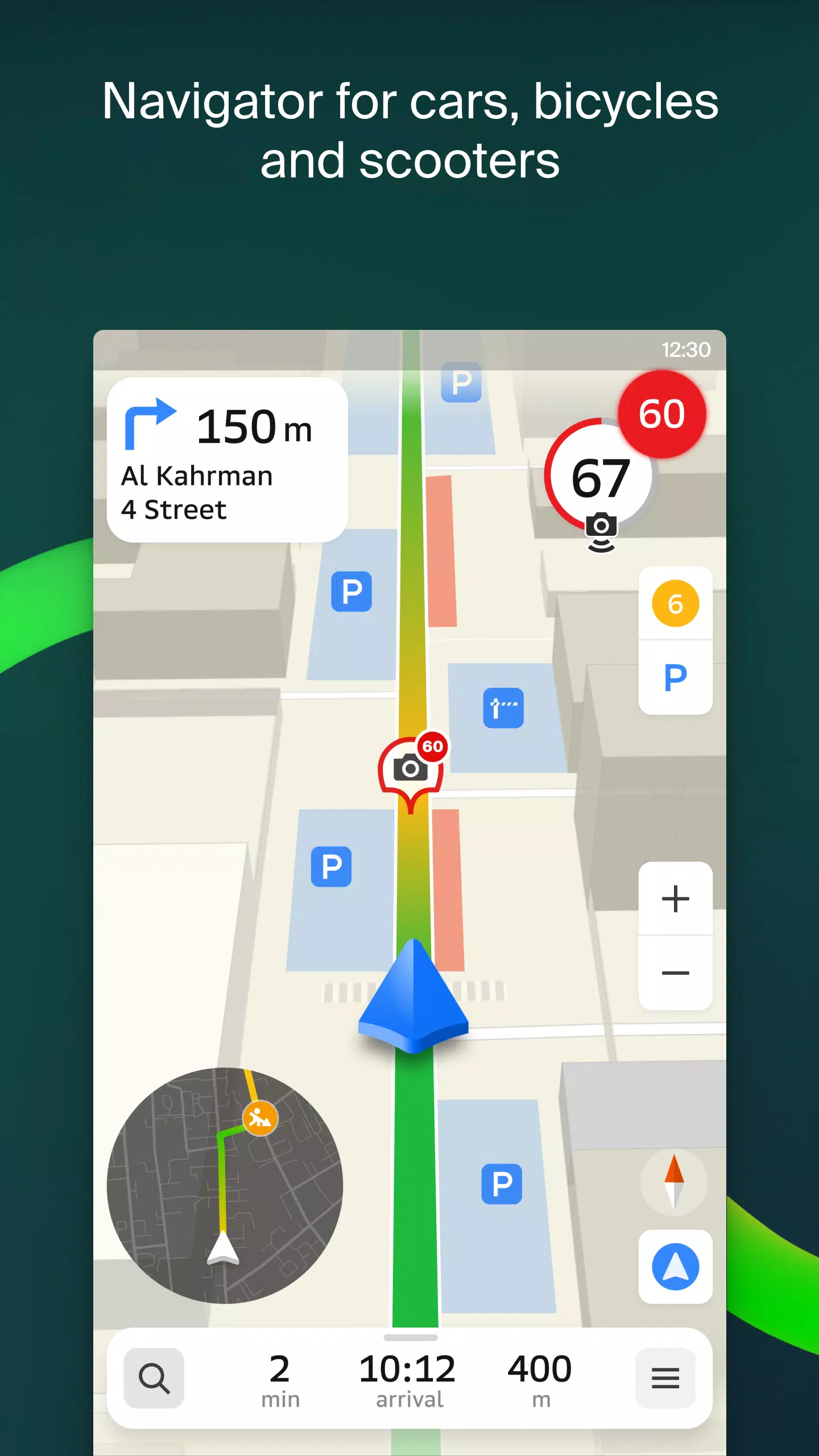
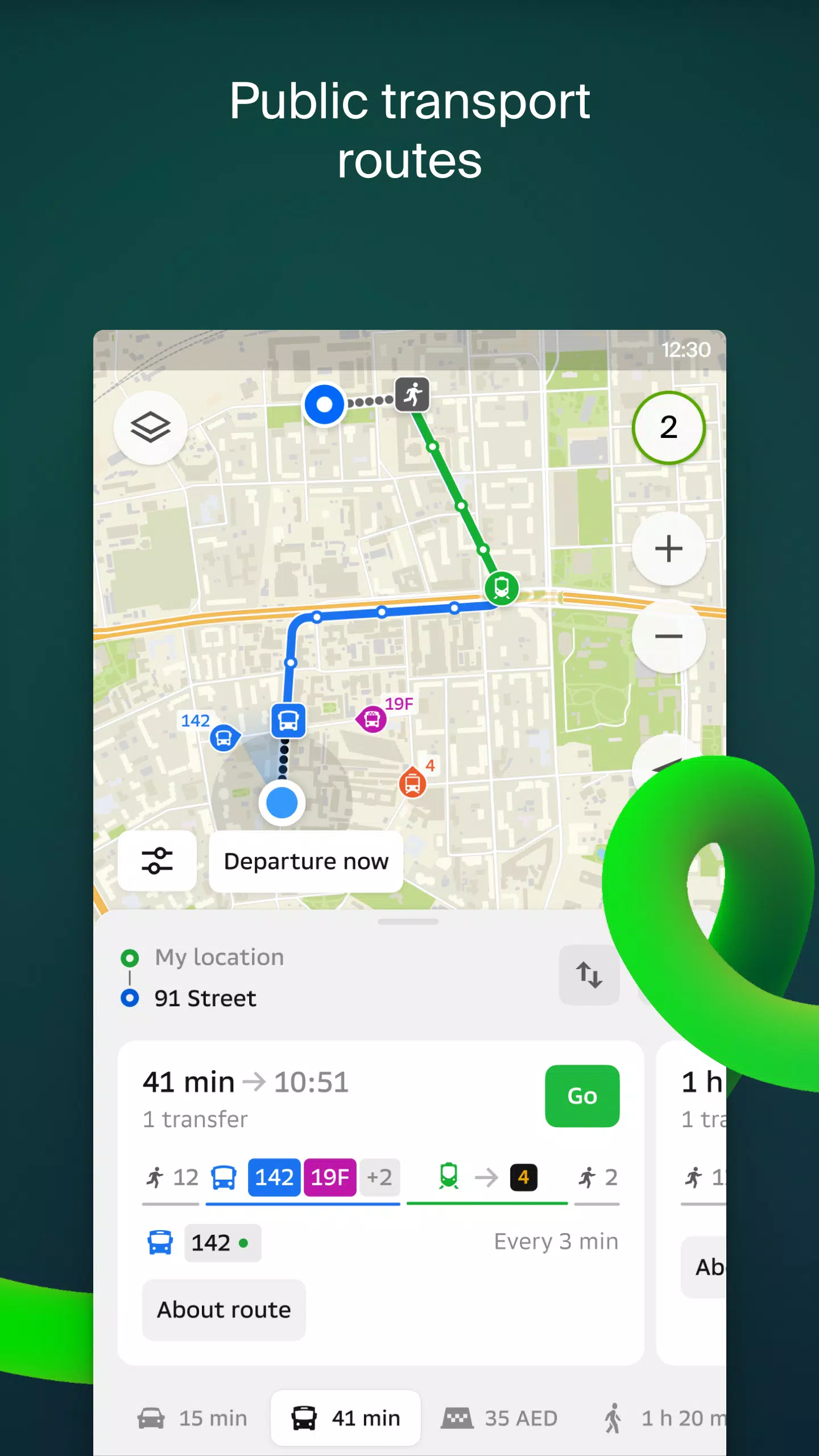
Transport and Navigation
Whether you're driving or using public transport, 2GIS has you covered. For drivers, the app offers voice-guided navigation, taking into account real-time traffic conditions and road closures. It dynamically updates your route if you stray from the planned path. For those on foot, 2GIS suggests various options including buses, metro, trains, cable cars, and river trams, ensuring you reach your destination efficiently.
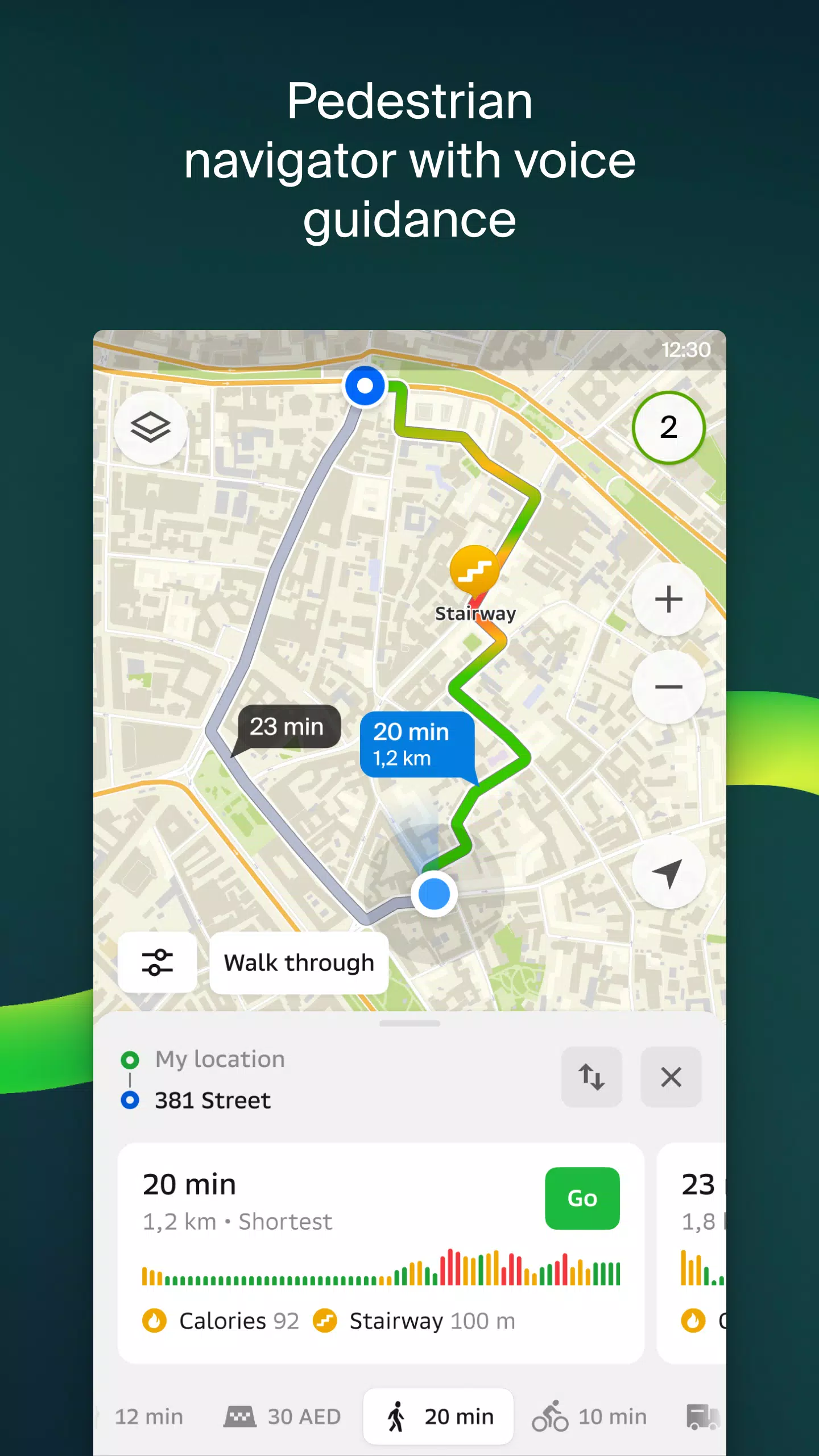
Walking Routes
Our pedestrian navigation feature maps out walkable routes, complete with background operation and voice guidance, making it easier for you to navigate on foot.
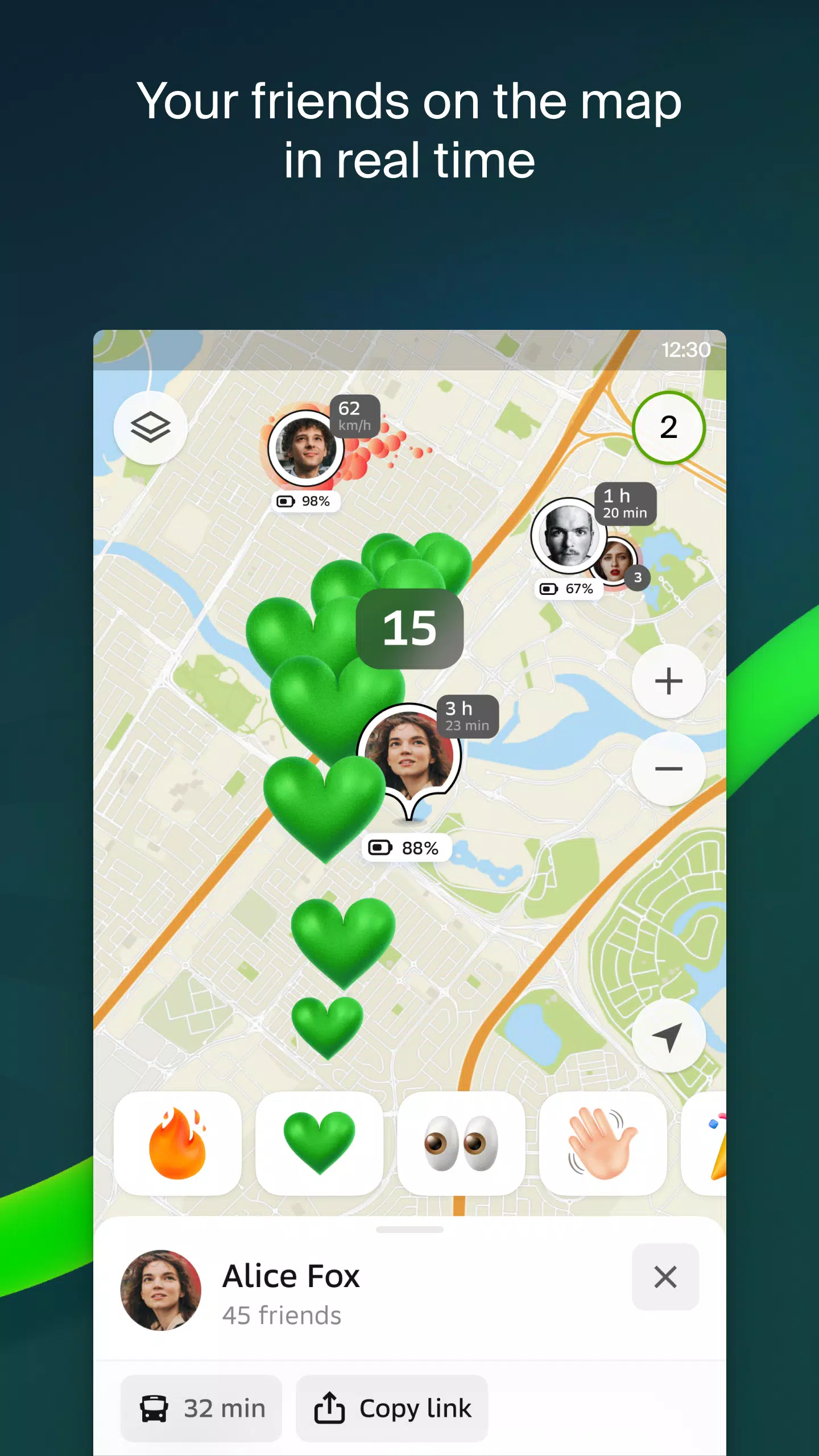
Friends on the Map
Stay connected with loved ones through 2GIS. You can now see the real-time location of your friends and family on the map. You have full control over who can see your location and who you can track, with customizable visibility settings.
Building Entrances
No more wandering around looking for the right entrance. 2GIS provides detailed information on how to access over 2.5 million companies. Whether you're arriving by public transport or by car, 2GIS directs you straight to the door.
Plans of Shopping Centers
Navigate effortlessly inside shopping centers with 2GIS. Find everything from shops and cafes to ATMs and restrooms, and plan your visit in advance to save time.
2GIS Beta Notifications Companion App for Smart Watches
Enhance your navigation experience with the 2GIS beta companion app for smart watches running Wear OS. This app offers route navigation for walking, cycling, or public transport directly from your wrist. View maps, receive maneuver hints, and get vibration alerts when nearing turns or bus stops. The app automatically syncs with your phone's navigation and is compatible with Wear OS 3.0 and later versions.
By participating in the 2GIS beta, you'll receive the latest updates as we fix bugs and errors, contributing to the development of a new version that millions will use. You can run both the original and beta versions simultaneously, easily switching between them as needed.
Support: [email protected]
What's New in the Latest Version 6.44.1.559.3
Last updated on Oct 19, 2024
We're thrilled to bring you beautiful, crisp updates in our latest version:
- Enjoy wide, realistic roads displayed on the main map and during route searches.
- Introducing Chats for Friends! Now you can message each other without leaving the map.
- Receive notifications when a friend is nearby, with the option to turn them off in settings.
- Just in time for ski season, we've added ski lift statuses on slopes, so you can check if they're operational.
- For public transport routes that include walking segments, we now calculate the walking portion in steps.
Screenshot
 Reviews
Post Comments+
Latest Apps
MORE+
Reviews
Post Comments+
Latest Apps
MORE+
-
 POPxo - Take It Up A Pop!
Communication 丨 11.60M
 Download
-
 Subject 9 — Motion Furry Comic
News & Magazines 丨 9.90M
Download
-
 Mangamo Manga & Comics
News & Magazines 丨 20.09M
Download
-
 King Social Auto Liker
Tools 丨 3.00M
Download
-
 Coub
Coub
Lifestyle 丨 109.60M
Download
-
 NaughtyDate
Lifestyle 丨 10.70M
Download
Similar recommendations
MORE+
Top News
MORE+


 Topics
MORE+
Topics
MORE+
- Essential Media and Video Tools for Android Users
- Best Apps for Following Current Events
- Top Photography Apps for Beginners
- Best Beauty Apps for Makeup Tutorials
- Realistic Simulation Games Collection
- Addictive Offline Games You Can Play Without Internet
- Top Casual Games for Mobile
- Top Multiplayer Battle Games for Android
Trending apps
MORE+
-
1

Migraine Buddy: Track Headache68.57M
Discover Migraine Buddy: Track Headache: Your Ultimate Migraine CompanionJoin the 3.5 million migraine sufferers who trust Migraine Buddy: Track Headache, the app designed to help you understand and manage your migraines. Here's how Migraine Buddy: Track Headache can help you: Pinpoint Patterns: Quickly identify triggers and patterns in your mi
-
2

Smart Life - Smart Living53.49M
The Smart Life app revolutionizes the way we control and manage our smart devices, bringing convenience and peace of mind to our everyday lives. This user-friendly app makes connecting and controlling a wide range of smart devices easier than ever before. Effortlessly set your devices to function ex
-
3

Обои для Стандофф 2 HD22.39M
Experience the adrenaline-pumping world of Standoff 2 like never before with "Wallpapers for Standoff 2." This must-have app is a treasure trove of vibrant and epic wallpapers that will transport you straight into the heart of the game. Whether you're a fan of popular characters, powerful weapons, t
-
4

RealVNC Viewer: Remote Desktop6.5 MB
Access your computer from anywhere using RealVNC Viewer! This Android app transforms your phone into a remote desktop, providing seamless control of your Mac, Windows, and Linux machines. RealVNC Viewer lets you remotely view and control your computer's desktop, mouse, and keyboard as if you were s
-
5

Cuevana 8 Mod11.43M
Cuevana 8 Mod APK is a leading app in the world of streaming, offering a wide range of high-quality movies and series. This app, which originates from the renowned Cuevana website, has been providing top-notch content for over two decades. Cuevana 8 Mod APK is popular for its user-friendly interface
-
6

Билеты ПДД 2023: экзамен ГИБДД36.35M
The Билеты ПДД 2023: экзамен ГИБДД app is your ultimate resource for acing the Russian theoretical driving exam. This comprehensive application covers all 40 exam questions and answers for categories ABM and CD, ensuring up-to-the-minute accuracy by referencing the official ГИБДД website. Prepare
20.9 MB
Download28.2 MB
Download82.4 MB
Download57.7 MB
Download169.7 MB
Download194.2 MB
Download